| Dist. |
Location |
Elevation |
Marking |
Description |
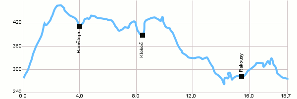
| 0,0 |
Malá Skála |
274 m n.m. |
 |
4099 |
| 4,0 |
Hamštejn |
416 m n.m. |
 |
Blue tourist track |
| 7,6 |
Rotštejn |
409 m n.m. |
 |
 4008 4008 |
| 8,4 |
Klokočí |
381 m n.m. |
 |
4099 |
| 9,4 |
Klokočské skály |
432 m n.m. |
  |
 4006 4006 |
| 15,5 |
Rakousy |
278 m n.m. |
 |
4170 |
| 18,7 |
Malá Skála |
274 m n.m. |
|
|
 | Rotštejn – The castle of Rotštejn located 7km North of Turnov. It can be dated back to 13th century, when Vok of Rotštejn was the owner of the whole vast area under Kozákov hill. The castle was abandoned during 15th century. The ruins were partially rebuilt and made accessible in 1922 by the Club of Czech Tourist and Beautification Club Klokočí. The top part of the castle is nowadays accessible with a guide. |  | Klokočské Skály (rocks)- These rocks are along with nearby Betlémské rocks a part of a natural reserve since 1985. There is also the biggest pseudokarst cave of the Bohemian Paradise, the Postojna cave sometimes called The America. |
|


