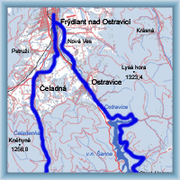
Length: 62,5 km
Dificulty: difficult
Bikes: mountain bike
For very savvy cyclists on mountain bikes.
The route leads mostly by road, paved roads, but the section Martiňák-Hlavatá leads in challenging hilly terrain, examining physically of cyclists, and his equipment. The rest of the road leads on the road.

|
|
 Click to show full-size map
|
| Dist. |
Location |
Elevation |
Marking |
Description |
| 0,0 |
Frýdlant nad Ostravicí |
357 m n.m. |
 |
cycle way no. 6008 |
| 6,0 |
Čeladná |
439 m n.m. |
 |
 cycle way no.6007 cycle way no.6007 |
| 10,5 |
Crossroad behind Hamry |
540 m n.m. |
 |
 cycle way no.46 cycle way no.46 |
| 18,5 |
Martiňák |
830 m n.m. |
 |
 cycle way no.472 cycle way no.472 |
| 28,0 |
Hlavatá |
780 m n.m. |
|
 cycle way no. 56, turn to junction of rivers Černá and Bíle Ostravice direction to Frýdlant cycle way no. 56, turn to junction of rivers Černá and Bíle Ostravice direction to Frýdlant |
| 35,0 |
Černá |
640 m n.m. |
|
 road 46420 road 46420 |
| 38,5 |
Staré Hamry |
500 m n.m. |
|
road 46420 |
| 49,5 |
Crossroad above the dam |
500 m n.m. |
 |
 cycle way no. 6113 cycle way no. 6113 |
| 56,6 |
Ostravice |
420 m n.m. |
 |
cycle way no.6007 |
| 62,5 |
Frýdlant nad Ostravicí |
357 m n.m. |
|
|
 | by river Čeladěnka |  | much of the trace leads on the road, climbing in the finish |  | this part leads in hilly terrain, hill 918 m.n.m. |  | by river Bílé Ostravice we fall through village Bílá |  | around water dam Šance |  | we return back to Frýdlant |
|
 Click to show full-size map


